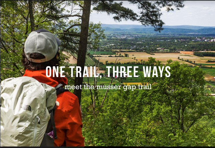
Intro: There are plenty of ways to explore the most recent addition to the Rothrock State Forest.
HIKE:
- Musser Gap Trailhead to Lion’s Valley Vista
- Difficulty: Moderate
- Time to Complete: 2-3 hours
- Distance: 3 mile out-and-back or 5 mile loop
- Time of Year: Year-round
- Fees: Free
Located five miles from town, Musser Gap Trail is an excellent introduction to Rothrock State Forest. Start from the information kiosk at the parking lot and follow the red-blazed trail, which climbs gently uphill through a few old farm fields and into the wooded forest. The gravel path becomes dirt after crossing a footbridge about one mile into the hike. From here, turn right onto the yellow-blazed Frog Hollow Trail.
Frog Hollow Trail is a short but steep dirt path leading uphill to the top of the ridge. Follow the sign to reach Lion’s Valley Vista, which overlooks State College. The view from Lion’s Valley Vista is spectacular at sunset.
For a 3-mile hike, simply retrace your steps back to the parking area. For a longer hike, follow Huckleberry Loop Trail south and descend slightly below the ridgeline. Reach a trail intersection and turn downhill to Mountain Mist Trail. Head east on Mountain Mist Trail and walk through a beautiful forest full of young hardwood trees.
A few minutes later you will reach Musser Gap Trail, which descends steeply at first, then mellows out while following the stream. Take notice of wildflowers, songbirds, and remnants of an old reservoir along this stream. Soon, Frog Hollow Trail appears on the left. Stay straight and follow the gravel path back to the parking lot.
Directions:
From downtown State College (Appalachian Outdoors): Drive west along Route 26 (College Avenue) for approximately 4 miles, then turn left on Route 45 eastbound. The gravel Musser Gap Parking Lot is on the south side of route 45, roughly one mile east of Route 26.
BIKE:
- A Taste of East Coast Mountain Biking
- Difficulty: Intermediate to difficult
- Time to Complete: 2-5 hours
- Distance: 14 mile loop
- Time of Year: Spring, summer, fall
- Fees: Free
Put your mountain biking skills to the test on this ride in Rothrock State Forest. The route includes some of the rockiest singletrack to be found, and by the end of the day you will learn what it takes to ride an IMBA Epic Route. Top it off with winding dirt paths and an excellent vista near the end of the ride.
Strap on your helmet at Musser Gap and crank uphill into the forest on a gravel path designed for hikers and bikers. Ascend through the gap, then head east on the dirt double track Mountain Mist Trail. Sweet singletrack begins on Lone Pine Trail and doesn’t end until Laurel Run Road, about four miles ahead. Red-White, Charcoal Flats, and Shingletown Gap trails will get you there.
Turn left onto Lower Trail, near a gate just before Laurel Run Road. Lower Trail is part of the 36-mile Rothrock Mix IMBA Epic. This trail is extremely rocky, technical, and fun; be prepared to hike-a-bike through several rock gardens and wooden bridges as you descend into Shingletown Gap.
Check your nerves crossing Roaring Run on a log bridge, then pump your legs on Blue-White Trail for the last climb of the day to Mountain Mist Trail. Relish this last section of singletrack ridge riding to Highline Vista, which offers views of Happy Valley several hundred feet below.
Turn left at the vista to follow the powerline cut, which is a fast dirt double track path the whole way back to Musser Gap Trail. Turn right onto Musser Gap Trail and descend nearly 1.5 miles back to the parking area.
Directions:
From downtown State College (Appalachian Outdoors): Drive west along Route 26 (College Avenue) for approximately 4 miles, then turn left on Route 45 eastbound. The gravel Musser Gap Parking Lot is on the south side of route 45, roughly one mile east of Route 26.
RUN:
- Trail Running Musser Gap Trail
- Difficulty: Intermediate
- Time to Complete: 1-2 hours
- Distance: 7-miles
- Time of Year: Spring, summer, fall
- Fees: Free
Experience a great mix of gravel paths, dirt double track, and rocky singletrack trails with this loop run beginning at the Musser Gap Trailhead. As an added bonus, you will pass two excellent vistas of the surrounding ridge and valley region.
Lace up your trail runners at Musser Gap Lot and warm up with an uphill jog along the gravel Musser Gap Trail. Run across Mountain Mist Trail, then climb a steep and rocky staircase reaching the ridgeline and Mid State Trail.
Catch your breath at Hubler Gap Vista and admire the ridges and valleys of Rothrock State Forest before tackling the technical ridge of Mid State Trail northeast to Deer Path. Engage your quads as you tear down Deer Path, but don’t miss the obscure left turn on Blue-White Trail, which connects to Mountain Mist Trail. Run superb singletrack along the leading ridge to Highline Vista, which offers views of Happy Valley several hundred feet below.
Turn left at the vista to follow the powerline cut, which is a fast dirt double track path the whole way back to Musser Gap Trail. Turn right onto Musser Gap Trail and burn rubber downhill for nearly 1.5 miles back to the parking area.
Directions:
From downtown State College (Appalachian Outdoors): Drive west along Route 26 (College Avenue) for approximately 4 miles, then turn left on Route 45 eastbound. The gravel Musser Gap Parking Lot is on the south side of route 45, roughly one mile east of Route 26.
Outro: Exploration is a spirit within all of us. The Musser Gap Trail offers a respite from everyday life, whether it’s a quick run, an all-day hike or a bike ride for the ages. It’s time to unplug from our always-on lives, turn on Explore Mode and connect in real life to the world, each other, and ourselves.